NASA now successfully has a map of the ocean floor from orbit with extreme precision, while announcing the development of the first dedicated nuclear reactor for long duration space mission, with the Space Reactor-1 “Freedom.”
The ocean floor has been, for most human history, a more reliable keeper of secrets than outer space. It’s was easier for humanity for map the Moon before getting any close to mapping the mid-Atlantic Ridge with any confidence.
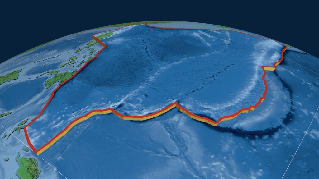
Now, with the Surface Water and Ocean Topography (SWOT) satellite’s next generation radar, scientists have successfully achieved high definition bathymetric chart survey of the ocean floor. The discovery revealed previously hidden geological structures across 70% of the planet.
Showcased through recent research and the agency’s Ignition conference, the twin developments demonstrated how satellite data and advanced propulsion are defining both oceanography and deep space exploration.
NASA’s SWOT Satellite Reveals Detailed Map of Earth’s Seafloor
An innovative world ocean bottom mapping product, effectively a map of the ocean floor, uses measurements from the Surface Water and Ocean Topography (SWOT) satellite to advance scientists’ understanding of the ocean. This breakthrough in seabed mapping allows researchers to detect minute variations in sea surface height caused by gravitational changes, producing a highly accurate seabed depth map.
Scientists can now use this approach to generate a map of the ocean floor far faster than traditional ship-based sonar methods, which have only covered about one-fourth of the seabed. These improvements in seafloor imaging are transforming how researchers interpret underwater landscapes and build bathymetric charts for scientific and commercial use.
The resulting data offers a more refined map of the ocean floor, revealing fine-scale features such as seamounts, ridges, and abyssal hills that are critical for understanding tectonic activity, ocean circulation, and climate systems. These insights are now being compiled into updated bathymetric charts, enhancing the accuracy of every labeled ocean floor map produced from satellite observations.
“Seafloor mapping is key in both established and emerging economic opportunities, including rare-mineral seabed mining, optimizing shipping routes, hazard detection, and seabed warfare operations,” said Nadya Vinogradova Shiffer, head of physical oceanography programs at NASA Headquarters, in Washington.
Among the most notable discoveries are abyssal hills, small but widespread formations that dominate the ocean floor. “Abyssal hills are the most abundant landform on Earth, covering about 70% of the ocean floor,” said Yao Yu, an oceanographer at Scripps Institution of Oceanography.
Yu added, “These hills are only a few kilometers wide, which makes them hard to observe from space. We were surprised that SWOT could see them so well.”
This capability strengthens each bathymetric chart derived from satellite data, refining how scientists interpret subsea terrain.
The satellite’s centimeter-level sensitivity enables detection of features previously invisible from orbit, potentially doubling the number of known seamounts worldwide. Scientists say this will enhance every map of the ocean floor and improve geological models, with outputs feeding into global datasets such as a NASA seafloor map. The mission, often described as NASA swot satellite seafloor mapping, represents a leap forward in large-scale seabed mapping and the production of a more detailed seabed depth map.
Nuclear Propulsion and Path to Mars
Alongside its Earth-focused breakthroughs, NASA is pushing forward with ambitious plans for deep space exploration. The agency announced it will launch Space Reactor-1 Freedom, the first nuclear-powered interplanetary spacecraft, before the end of 2028.
Designed to demonstrate advanced nuclear electric propulsion in deep space, the spacecraft could enable high-power missions beyond Jupiter, where solar energy becomes ineffective. It will also deploy a payload of helicopters on Mars, building on earlier aerial exploration efforts.
“Freedom will establish flight heritage nuclear hardware, set regulatory and launch precedent and activate the industrial base for future fission power systems across propulsion, surface and long-duration missions,” NASA said.
The mission is part of a broader strategic pivot that includes scaling back the Lunar Gateway project in favor of building a permanent human presence on the Moon’s surface, alongside expanded robotic deployments and infrastructure development.
Meanwhile, the SWOT mission continues to redefine how scientists observe Earth, with each new bathymetric chart and every refined bathymetric chart method contributing to a clearer planetary picture.
“The SWOT satellite was a huge jump in our ability to map the seafloor,” said geophysicist David Sandwell.
Inside Telecom provides you with an extensive list of content covering all aspects of the tech industry. Keep an eye on our Tech sections to stay informed and up-to-date with our daily articles.